
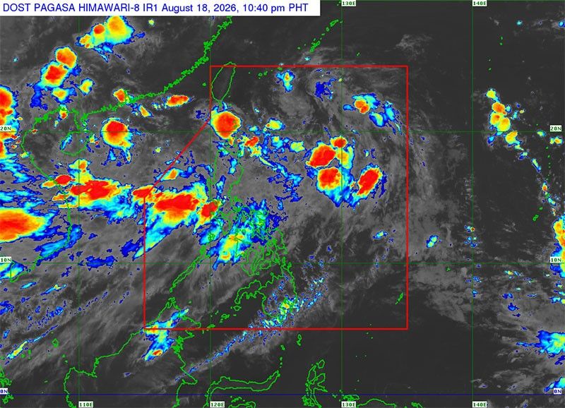
MANILA, Philippines — Tropical Depression Neneng has developed inside the Philippine area of responsibility (PAR) and while it will not make landfall, the Philippine Atmospheric, Geophysical and Astronomical Services Administration (PAGASA) said it might pull the winds of the southwest monsoon.
Neneng developed around 2 p.m. yesterday and was last located 1,025 kilometers east of extreme Northern Luzon, moving northwestward at 20 kms per hour. It is packing winds of 45 kph with gusts of 55 kph.
Neneng is the 14th tropical cyclone this year and the third this month, after Luis and Maymay.
Meanwhile, another tropical depression is lurking outside PAR – 3,160 kms east of northeastern Mindanao and packing winds of 45 kph and gusts of 55 kph while almost stationary.
A low-pressure area is also within PAR, last located 450 kms west of Calayan, Cagayan, with a high chance of developing into a tropical cyclone in the next 24 hours.
Should the LPA develop or the tropical cyclone enter PAR, whichever comes first, it will have the local name Obet.
State meteorologists said the southwest monsoon will bring a “severe” level of impact in parts of Luzon tomorrow.
Expected to feel the effects are Bataan (Hermosa and Dinalupihan), Bulacan (Calumpit, Malolos, Paombong and Hagonoy), and Pampanga (Lubao, Floridablanca, Sasmuan, Macabebe, Masantol and Apalit).
Under the “severe” level, prolonged and widespread disruption to day-to-day routine and damage to households and businesses are expected.
Meanwhile, Zambales and other parts of Bataan, Bulacan and Pampanga may experience “significant” impact due to the monsoon.
Metro Manila, Nueva Ecija, Rizal, Tarlac along with some parts of Batangas, Bulacan, Cavite, Laguna, and Pampanga may feel minor impacts while Quezon, and remaining parts of Batangas, Bulacan and Cavite and Laguna will experience “minimal” impacts also due to the monsoon.
PAGASA’s new Severe Winds Impact-based Forecast (IBF) assesses the threat of a tropical cyclone to a specific city or municipality, depending on their exposure and vulnerability.
The potential damage is then categorized and color-coded based on four levels of impact severity – minimal (green), minor (yellow), significant (orange) to severe (red).
PAGASA said they are still developing the IBF for flood, storm surge and landslides.
Several areas will continue to experience rains amid the monsoon until Friday.
Orange rainfall warning or 100 to 200 millimeters of rain are expected in Benguet, La Union, Pangasinan, Zambales, Bataan and Occidental Mindoro this afternoon until tomorrow afternoon.
Ilocos Sur, Abra, Tarlac, Pampanga, Bulacan, Nueva Ecija, Metro Manila, Cavite, Batangas, Rizal and Oriental Mindoro will be under yellow rainfall alert on the same timeframe.
From tomorrow afternoon to Friday afternoon, only Ilocos Norte, Ilocos Sur, Abra, La Union, Benguet, Pangasinan, Zambales, Bataan and Occidental Mindoro will be under yellow rainfall warning.
Meanwhile, monsoon rains will be experienced in Zambales, Bataan, Cavite, Batangas, Occidental Mindoro and Oriental Mindoro.
It will also bring occasional rains in Metro Manila, Ilocos Sur, La Union, Pangasinan, Abra, Benguet, Tarlac, Pampanga, Bulacan, Nueva Ecija, Laguna, Rizal and Antique.
Cloudy skies with scattered rains and thunderstorms will be felt in Negros Island Region, the rest of Luzon and the rest of Western Visayas. Partly cloudy to cloudy skies with isolated rainshowers or thunderstorms will be felt in the rest of the Visayas.
Partly cloudy to cloudy skies with isolated rainshowers or thunderstorms will be felt in Mindanao due to localized thunderstorms. — Brix Lelis, Josiah Antonio, Artemio A. Dumlao, Ghio Ong, Emmanuel Tupas