
PHILIPPINES— Signal No. 3 is up in parts of Visayas and Mindanao as Typhoon “Odette” continues to intensify and may make its first landfall on Thursday afternoon over Dinagat Islands-Surigao provinces, according to the state-run weather agency.
The Philippine Atmospheric, Geophysical and Astronomical Services Administration (Pagasa) said in its 5 a.m. advisory that affected areas in Visayas include Southern Leyte, the southern portion of Leyte (Abuyog, Mahaplag, City of Baybay, Inopacan, Hindang, Hilongos, Bato, Matalom and Javier), Bohol, and the eastern portion of Cebu (Lapu-Lapu City, Cordova, Carmen, Danao City, Compostela, Liloan, Consolacion, Mandaue City, Cebu City, City of Talisay, Minglanilla, City of Naga and San Fernando) including Camotes Islands.
In Mindanao, Signal No. 3 is up over:
Dinagat Islands, Surigao del Norte, the northern portion of Agusan del Norte (Tubay, Santiago, Jabonga and Kitcharao), and the northern portion of Surigao del Sur (Carrascal, Cantilan, Madrid, Carmen, Lanuza and Cortes).
Pagasa said Signal No. 2 is raised over mainland Masbate, Ticao Island, Romblon and Cuyo Islands in Luzon while the same storm signal is raised over Northern Samar, Eastern Samar, Samar, Biliran, the rest of Leyte, the rest of Cebu including Bantayan Islands, Negros Oriental, Negros Occidental, Siquijor, Guimaras, Iloilo, Antique, Capiz and Aklan in Visayas.
Signal No. 2 is also over the rest of Surigao del Sur, the rest of Agusan del Norte, Agusan del Sur, the northern portion of Bukidnon (Malitbog, Impasug-Ong and Manolo Fortich), Misamis Oriental, Camiguin, the extreme northern portion of Misamis Occidental (Sapang Dalaga, Baliangao, Plaridel, Calamba, Lopez Jaena and Oroquieta City), and the extreme northern portion of Zamboanga del Norte (Dipolog City, Dapitan City, Sibutad and Rizal).
The weather bureau said Signal No. 1 is up over Catanduanes, Camarines Norte, Camarines Sur, Albay, Sorsogon, Burias Island, Marinduque, the southern portion of Quezon (San Antonio, Tiaong, Candelaria, Sariaya, Dolores, Lucena City, Pagbilao, Padre Burgos, Atimonan, Agdangan, Unisan, Gumaca, Plaridel, Pitogo, Lopez, Guinayangan, Buenavista, Catanauan, General Luna, Macalelon, Mulanay, San Narciso, San Andres, San Francisco, Tagkawayan, Calauag, Quezon, Alabat, City of Tayabas and Perez), Batangas, Oriental Mindoro, Occidental Mindoro, and the northern and central portions of Palawan (San Vicente, Roxas, Taytay, Dumaran, Araceli, El Nido, Puerto Princesa City, Quezon, Narra, Sofronio Española and Aborlan) including Calamian, Cagayancillo and Kalayaan Islands in Luzon.
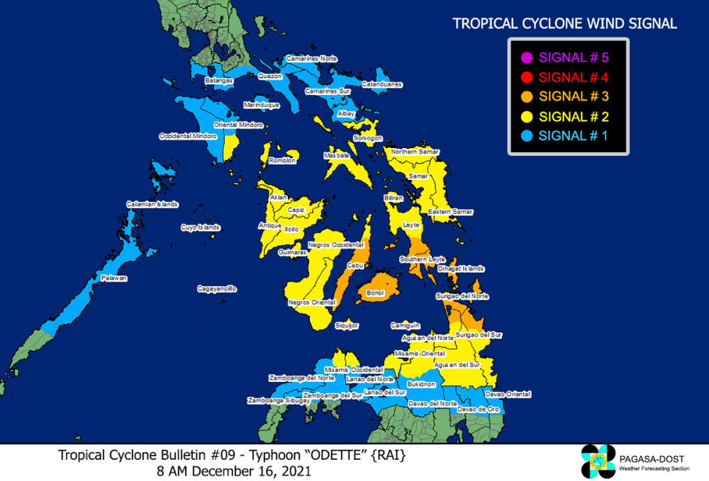
In Mindanao, same storm signal is raised over the northern portion of Davao Oriental (Baganga, Cateel and Boston), the northern portion of Davao de Oro (Laak, Mawab, Nabunturan, Montevista, Monkayo, New Bataan and Compostela), the northern portion of Davao del Norte (Talaingod, Santo Tomas, Kapalong, Asuncion, San Isidro and New Corella), the rest of Misamis Occidental, the rest of Bukidnon, Lanao del Norte, Lanao del Sur, the northern portion of Zamboanga del Norte (Labason, Kalawit, Tampilisan, Liloy, Salug, Godod, Bacungan, Sindangan, Siayan, Jose Dalman, Manukan, Pres. Manuel A. Roxas, Katipunan, Sergio Osmeña Sr., Polanco, Piñan, Mutia, La Libertad, Gutalac and Baliguian), the northern portion of Zamboanga del Sur (Bayog, Lakewood, Kumalarang, Guipos, Mahayag, Dumalinao, Tukuran, Tambulig, Ramon Magsaysay, Aurora, Molave, Sominot, Tigbao, Labangan, Josefina, Pagadian City, Midsalip and Dumingag), and the northern portion of Zamboanga Sibugay (Titay, Ipil, Naga, Kabasalan, Siay, Diplahan and Buug).
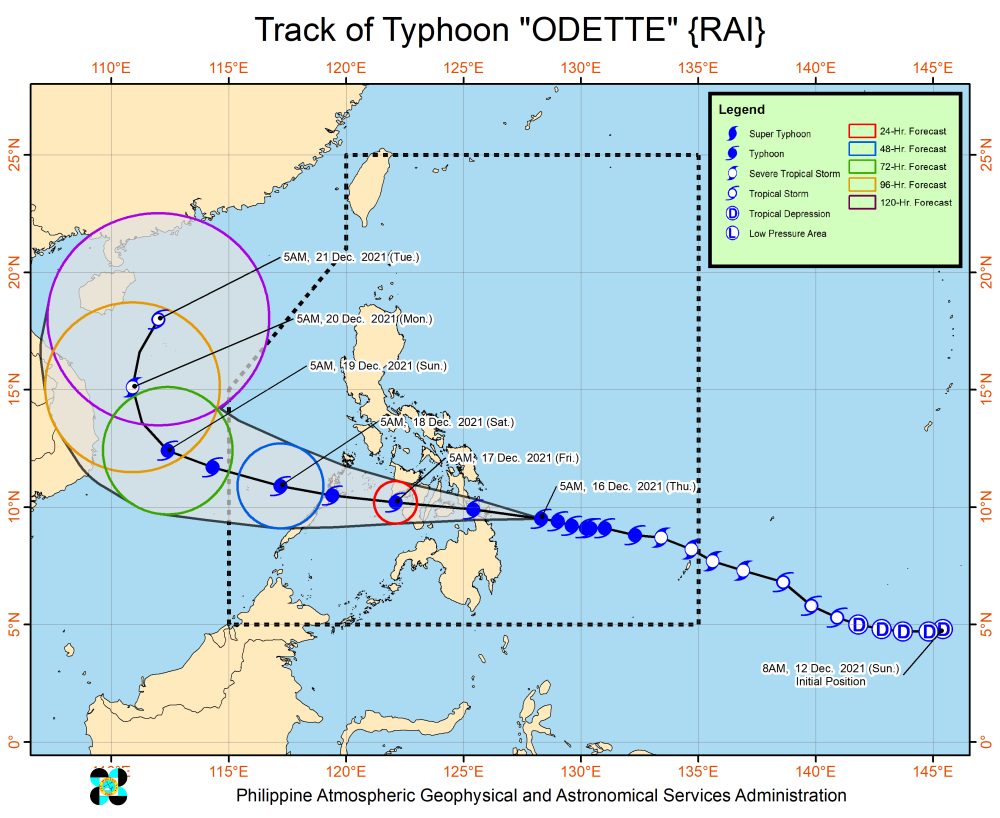
With the eye of the typhoon estimated at 330kilometers east of Surigao City, Surigao del Norte, its maximum sustained winds are at 150 kilometers per hour (kph) near the center and gustiness of up to 185kph, Pagasa said.
It is moving west-northwestward at the speed of 25kph, it said.
“The center of its eye is forecast to make landfall in the vicinity of Dinagat Islands, Siargao-Bucas Grande Islands, or the northern portion of Surigao del Sur this Thursday afternoon,” Pagasa said.
“Afterwards, the center of Odette will move westward and cross several provinces in Central and Western Visayas regions before emerging over the Sulu Sea Friday morning,” it added.
The typhoon is likely to cross the northern or central portion of Palawan Friday afternoon or evening before emerging over the West Philippine Sea, the weather agency said.
Odette may see some slight weakening as it crosses north-eastern Mindanao, Visayas, and Paadlawan but it is forecast to remain as a typhoon, it said.
Until Friday morning, Pagasa said heavy to torrential rains may prevail over Caraga, Central Visayas, Misamis Oriental, Camiguin, Southern Leyte, and Negros Occidental while moderate to heavy with at times intense rains will be likely over Leyte, the southern portions of Eastern Samar and Samar, Zamboanga del Norte, Lanao del Sur, and the rest of Northern Mindanao.
Light to moderate with at times heavy rains will be experienced over Bicol Region, Davao Oriental, Davao de Oro, Davao del Norte, Quezon, and the rest of Visayas, Zamboanga Peninsula, and mainland Bangsamoro.
By Friday until Saturday morning, heavy to intense with at times torrential rains may prevail over Central Visayas, Western Visayas, and Palawan including Calamian Islands, Cuyo, and Cagayancillo Islands while moderate to heavy with at times intense rains will be likely over Bicol Region, Zamboanga Peninsula, Quezon, Occidental Mindoro, Oriental Mindoro, Romblon, Marinduque, Lanao del Norte, Lanao del Sur, and the rest of Visayas.
Meanwhile, Caraga, the southern portion of Aurora, and the rest of Northern Mindanao will experience light to moderate with at times heavy rains.
By Saturday until Sunday morning, Pagasa said heavy to torrential rains will be experienced over Kalayaan Islands while light to moderate with at times heavy rains over mainland Palawan and Calamian Islands.
Metro Manila and the rest of Luzon will have generally fair weather condition but it may experience partly cloudy to cloudy skies with isolated light rains due to the northeast monsoon or “amihan.”