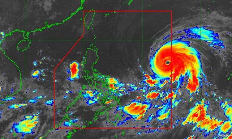
Metro Manila, Philippines— The state weather bureau on Saturday morning raised Tropical Cyclone Wind Signal No. 1 over parts of Cagayan, including Babuyan and Camiguin Islands, and parts of Isabela as Super Typhoon Betty maintained its strength.
In its 11 a.m. update, the Philippine Atmospheric, Geophysical and Astronomical Services Administration (PAGASA) said Signal No. 1 – an alert for “strong winds” – has been hoisted over the eastern portion of Cagayan, particularly Santa Ana, Gonzaga, Lal-Lo, Gattaran, Baggao, Peñablanca, Santa Teresita, Buguey, and Babuyan and Camiguin Islands.
In Isabela, the affected areas are the eastern portion of the province, namely Maconacon, Divilacan, Dinapigue, Palanan, San Mariano, Ilagan City, Tumauini, San Pablo, and Cabagan.
Signal No. 1 means there is minimal to minor threat to life and property, according to PAGASA.
Called “Mawar” before entering the Philippine Area of Responsibility (PAR) early Saturday morning, the super typhoon left residents of the US territory of Guam dealing with widespread damage, water supply issues, and power outages with its hurricane-force winds and heavy rainfall.
According to PAGASA, Betty is the strongest tropical cyclone to enter the Philippines this year.
It was packing maximum sustained winds of 85 kilometers per hour (kph) and gustiness of up to 105 kph as of 10 a.m. and is expected to remain a super typhoon over the weekend.
PAGASA added that short-term intensification is possible over the next 12 to 24 hours.
However, it said the tropical cyclone may begin weakening considerably on Monday or Tuesday.
From Monday morning to Tuesday morning, it said light to moderate rains are expected over Batanes, Babuyan Islands, and the northern portions of mainland Cagayan, Ilocos Norte, and Apayao.
Heavier rainfall is expected from Tuesday morning to Wednesday morning, particularly over Batanes.
In that same period, PAGASA forecasts moderate to heavy rains over Babuyan Islands, Ilocos Norte, Ilocos Sur, and La Union; and light to moderate rains over Cordillera Administrative Region and the northern portion of mainland Cagayan.
It also noted that rainfall is likely generally higher in elevated or mountainous areas.
As of 10 a.m, PAGASA said Betty was spotted 1,170 kilometers east of Central Luzon, moving west northwestward at 30 kph.
It said the tropical cyclone may eventually become almost stationary between late Tuesday and early Wednesday when it will be closest to Batanes.
Meanwhile, PAGASA advised against sailing for small vessels in the eastern and northern seaboards of Luzon, as well as the eastern coast of the Visayas because of rough seas.
Effects of southwest monsoon
Despite not being directly affected by the super typhoon, PAGASA said rains are also possible over the western sections of Mimaropa, the Visayas, and Mindanao on Sunday due to enhanced southwest monsoon or “habagat.”
On Monday and Tuesday, monsoon rains are likely over the western sections of Mimaropa and Western Visayas, and possible over the rest of Mimaropa and Western Visayas.
The bureau also warned that flooding and rain-induced landslides are likely under these conditions, especially in areas that are highly or very highly susceptible to these hazards.

