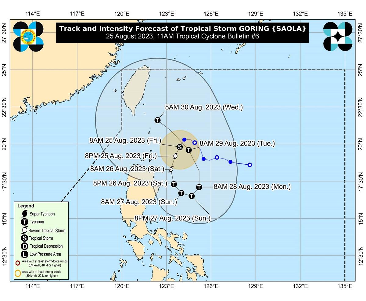
Tropical Cyclone Wind Signal (TCWS) No. 1 remains hoisted over four areas as Tropical Storm Goring continued to intensify on Friday, state weather bureau PAGASA said.
In its 11 a.m. bulletin, PAGASA said TCWS No. 1 is raised over the following areas:
- Batanes
- the eastern portion of Babuyan Islands (Babuyan Island, Camiguin Island)
- the eastern portion of mainland Cagayan (Santa Ana, Gonzaga, Lal-Lo, Gattaran, Baggao, Peñablanca, Santa Teresita, Buguey, Camalaniugan, Aparri)
- the eastern portion of Isabela (Maconacon, Divilacan, Palanan, Dinapigue, San Mariano, San Pablo, Cabagan, Tumauini, Ilagan City)
Goring was located 225 kilometers east southeast of Basco, Batanes or 270 km east of Calayan, Cagayan packing a maximum sustained winds of 85 km per hour and gustiness of up to 105 km/h.
It was moving south southwestward slowly, according to PAGASA.
Several local government units are preparing for the possible effects of Goring, according to a report of GMA Regional TV One North Central Luzon’s Breves Bulsao on GTV’s Balitanghali.
In Batanes, no sailing policy has been imposed as occasional rain showers are already being experienced in the area.
The Batanes Provincial Disaster Risk Reduction and Management Office (PDRRMO) said it has enough supply of relief goods for residents who will be affected by the weather disturbance.
In Cagayan, no sailing policy is also in effect.
Cagayan PDRRMO tagged the following as “areas of immediate concern” in light of Goring: Santa Ana, Aparri, Gonzaga, Santa Teresita, Buguey, Baggao, Peñablanca, Gattaran, Lal-lo, and Calayan.
Rescue personnel from the Armed Forces of the Philippines and Philippine Coast Guard have been deployed.
The Office of Civil Defense in Cordillera is also preparing for the possible effecta of Goring on the region, the report said.
A forecast accumulated rainfall of 50 to 100 millimeters is expected over Batanes, Babuyan Islands, and the northeastern portion of mainland Cagayan from Friday to Saturday noon, PAGASA said.
Forecast rainfall is generally higher in elevated or mountainous areas, it noted.
“Under these conditions, flooding and rain-induced landslides are possible especially in areas that are highly or very highly susceptible to these hazards as identified in hazard maps and in localities that experienced considerable amounts of rainfall for the past several days,” PAGASA said.
Due to the Southwest Monsoon or Habagat that is enhanced by Goring, occasional rains may be experienced over the western portions of Central Luzon and Southern Luzon starting Saturday.
Minimal to minor impacts from strong winds are expected in areas under TCWS No. 1, according to PAGASA. Local winds may be slightly stronger in coastal and upland/mountainous areas exposed to winds.
The enhanced Habagat will also bring gusty conditions in other areas that are not under TCWS on Saturday. These are Aurora, Bataan, Metro Manila, CALABARZON, Bicol Region, Dinagat Islands, and most of MIMAROPA and Visayas.
Gale Warning is in effect over the coastal waters of Batanes, Babuyan, and the northern coast of mainland Cagayan due to strong winds linked to Goring, which may cause sea travel to be risky for certain types or tonnage of vessels.
“Disruption in civilian maritime activities is expected over these areas,” PAGASA said.
PAGASA said Goring is forecast to rapidly intensify and may reach typhoon category by Saturday and may reach its peak intensity on Sunday evening.
“The potential for developing into a super typhoon is not ruled out,” PAGASA said.
The tropical cyclone is expected to move south southwestward or southward over the waters east of Northern Luzon until Saturday evening, then turn generally south or southeastward for the rest of Saturday through Sunday afternoon.
It will then loop northward before turning to the northwest on Tuesday towards Luzon Strait. —Joviland Rita/KBK/ VAL, GMA Integrated News
