
Tropical Depression Jenny has intensified into a tropical storm (international name: Koinu) and may enhance the Southwest Monsoon (Habagat), PAGASA said in its forecast on Saturday.
At 4 a.m., the center of Jenny was estimated to be located at 1,145 km east of Central Luzon.
Jenny has maximum sustained winds of 65 km/h near its center, gustiness of up to 80 km/h, and central pressure of 1000 hPa.
The tropical storm is moving westward at 15 km/h
From its center, strong to gale-force winds are extending outwards up to 330 km.
PAGASA said it has not raised any tropical cyclone wind signals (TCWS) at this time.
“Tropical Storm JENNY is not directly affecting the country at this time. However, due to the proximity of the track forecast to Extreme Northern Luzon, heavy rainfall over Batanes and Babuyan Islands may be experienced on Tuesday or Wednesday,” the weather bureau said.
On Sunday or Monday, TCWS may be hoisted over Extreme Northern Luzon in anticipation of severe winds from Jenny. However, PAGASA may raise TCWS earlier should there be changes in the forecast scenario.
Habagat
Jenny may also enhance the Southwest Monsoon (Habagat), thus rains may be expected over the western portions of Southern Luzon and Visayas on Sunday.
Gusty conditions may be felt in the following areas not under any TCWS, especially in coastal and upland or mountainous areas exposed to winds:
- Sunday: Palawan, Romblon, most of Visayas, and Dinagat Islands; and
- Monday: Most of Mimaropa and Visayas, and Dinagat Islands.
Coastal waters
Moderate to rough seas may occur over the coastal waters of Extreme Northern Luzon and northern mainland Cagayan on Monday due to Jenny.
“Mariners of motor bancas and similarly-sized vessels are advised to take precautionary measures while venturing out to sea and, if possible, avoid navigating in these conditions, especially if inexperienced or operating ill-equipped vessels,” PAGASA said.
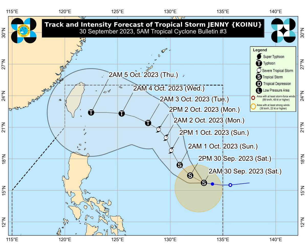
Track, intensity outlook
On Saturday, Jenny may move west northwestward then northwestward or north northwestward on Sunday until Monday.
On Tuesday, Jenny is forecast to turn west northwestward towards the Luzon Strait-Southern Taiwan area.
“A landfall or close approach scenario over Extreme Northern Luzon or northeastern mainland Cagayan is not ruled out since these scenarios are within the forecast confidence cone,” PAGASA said.
The tropical storm is also expected to intensify further and become a severe tropical storm on Sunday, then develop into a typhoon on late Monday or on Tuesday.
PAGASA advised the public and disaster risk reduction and management offices concerned to take all necessary measures to protect life and property.
The weather bureau will issue its next tropical cyclone bulletin at 11 a.m. —KG, GMA Integrated News