
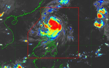
(DOST-PAGASA Satellite Image)
MANILA – Julian has intensified into a severe tropical storm category, the weather bureau said Sunday morning.
Severe tropical storm Julian was last seen 305 km. east of Aparri, Cagayan with maximum sustained winds of 95 kph near the center, and gustiness of up to 115 kph, according to the tropical cyclone bulletin of the Philippine Atmospheric, Geophysical and Astronomical Services Administration (PAGASA) issued at 5 a.m.
Julian is moving west-northwestward at 10 kph.
Tropical Cyclone Wind Signal (TCWS) No. 2 has been hoisted in the northeastern portion of Mainland Cagayan (Santa Ana) and the eastern portion of Babuyan Islands (Camiguin and Babuyan Islands).
Meanwhile, Batanes, the rest of Cagayan, the rest of Babuyan Islands, Isabela, Apayao, Abra, Kalinga, the eastern and central portions of Mountain Province (Natonin, Paracelis, Sadanga, Barlig, and Bontoc), the eastern portion of Ifugao (Aguinaldo, Alfonso Lista, and Mayoyao), Ilocos Norte, the northern portion of Ilocos Sur (Sinait, Cabugao, San Juan, Magsingal, Santo Domingo, Bantay, San Ildefonso, and San Vicente), and the northern portion of Aurora (Dilasag, Casiguran) have been placed under TCWS No. 1.
The highest tropical cyclone wind signal due to Julian could reach Signal No. 4, the weather bureau warned.
Julian will continue to intensify and reach typhoon category Sunday evening or Monday early morning.
PAGASA added there is a “high chance of rapid intensification, and the possibility of reaching super typhoon category is not ruled out.”
A landfall or close approach scenario by Monday over Batanes and/or Babuyan Islands is “highly likely.”